文章导读
用基于自然的解决方案改善基础设施建设是缓解洪水风险和增强城市抵御能力的可行策略。本研究基于极端降水指数拟合了北京市的洪水风险函数,分析了北京市发生洪水灾害的概率及其经济损失。然后确定了洪水风险的主要驱动因素及其空间关系,特别是蓝色、绿色和灰色基础设施的影响。研究表明,相较蓝色基础设施,北京市绿色基础设施发挥了更为有效的洪水风险减缓作用,而灰色基础设施加剧了洪水风险,尤其是东北部郊区和西南部郊区。该研究为快速城市化城市的基础设施建设和洪水管理决策提供了重要参考。
研究结果
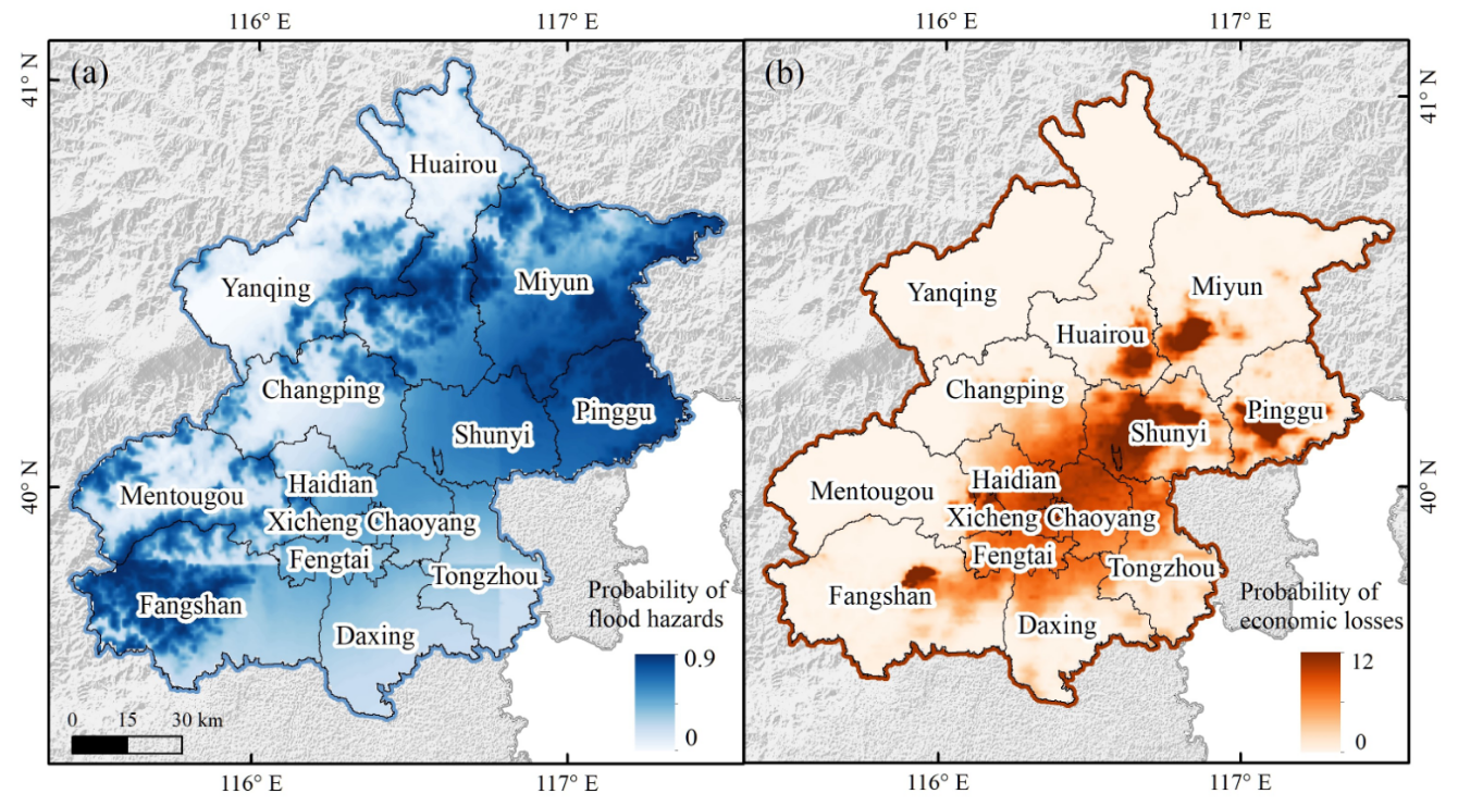
北京市洪水灾害的风险概率整体呈现由西北地区向东南地区递减的空间态势,而洪水经济损失整体呈现由东南地区向周边递减的趋势。具有较低洪水风险的地区往往会在灾害发生时遭受更高的直接经济损失,尤其在密云区、平谷区等远郊区,以及房山区、通州区等近郊区。

The relationship between extreme precipitation events and flood risks: (a) RX5day; (b) R20mm
*Note: When extreme precipitation events of equal magnitude occur, the probability of flood hazards around Yanqing Station is higher, while the probability around Miyun Station is relatively lower. When Rx5day>120mm or R20mm>180mm, the probability of flood hazards around Yanqing Station approaches 1. When Rx5day>250mm or R20mm>300mm, the probability around Beijing Station and Miyun Station approaches 1.

The spatial distribution of flood risks (a) and economic losses (b)
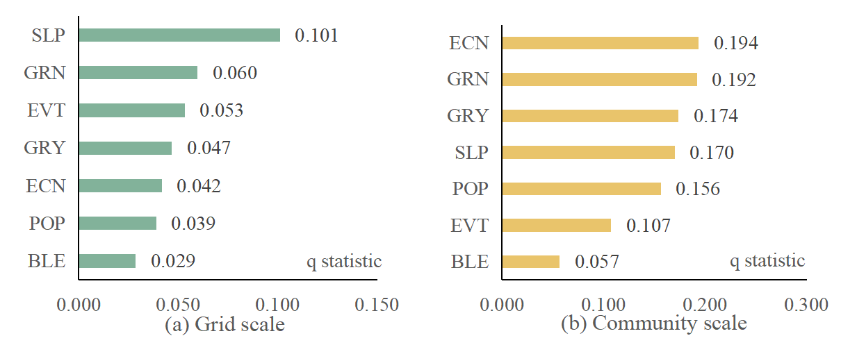
社会经济发展对洪水风险空间分异的解释能力依赖于研究尺度的变化而变化。自然地形是网格尺度洪水风险空间异质性的主要驱动因素(q statistic=0.101),而社会经济发展是社区尺度洪水风险的主要驱动力(q statistic=0.194)。作为解释洪水风险空间分异的关键驱动因子,坡度、经济强度、绿色基础设施与其他因子(如蓝色基础设施)交互作用能够显著提升对洪水风险空间分异的解释力度。

Detection of driving factors for spatial heterogeneity in flood risks at grid scale (a) and community scale (b)
(a) Grid scale

(b) Community scale
Detection of interactive factors of spatial heterogeneity in flood risks at grid scale (a) and community scale (b)
各类基础设施对洪水风险的作用程度依次为:绿色基础设施(βmin=-0.28)>灰色基础设施(βmax=0.13)>蓝色基础设施(βmin=-0.2),其中绿色基础设施发挥了重要的减缓作用,蓝色基础设施对洪水风险的减缓作用仍有待提高。
绿色基础设施在东北部远郊区,如密云区、平谷区,对洪水风险发挥了有效的缓解作用;蓝色基础设施在西部地区,如房山区、门头沟区、昌平区等近郊区、延庆区,发挥了较为显著的缓解作用;灰色基础设施建设加剧了洪水风险发生概率,尤其在密云区、平谷区等远郊区。

Attribution effects of classified infrastructure on flood risks: (a) Green infrastructure; (b) Blue infrastructure; (c) Grey infrastructure
*Note: The results were divided into five classes (Class I-V) according to the attributing effects of infrastructure on flood risks by integrating the natural breakpoint method and maximum-minimum method. Class I-II represents a negative attributing effect, indicating that infrastructure distribution may aggravate urban flood risks, Class III represents a weak attributing effect, and Class IV-V represents a positive attributing effect, indicating a potential role in mitigating urban flood risks.
中心城区、东北部远郊区、西南部近郊区是规划基础设施减缓城市洪水风险的关键地带。高风险社区往往呈现绿色基础设施密度低但灰色基础设施密度高的特征;低风险社区往往呈现绿色基础设施密度高但灰色基础设施密度低的特征。

Key communities for mitigating flood risks: (a) High-risk zone; (b) Low-risk zone
讨论
研究提供了一种洪水风险概率拟合模型,即基于Logistic模型拟合了洪水风险函数。相比于指标评估方法,该方法能够降低人为因素的扰动,较好量化了洪水发生的风险概率和损失分布。类似方法可以拓展至同类快速增长的城市地区。我们将研究结果与以往研究进行了对比验证(Liu et al., 2016; Wang et al., 2020),同时这一研究也符合多年来北京市洪水灾情的实际情况。2023年7月29日至8月2日,一场特大洪水灾害袭击北京,房山区和门头沟区受灾最为严重(Conroy, G., 2023)。我们的研究发现,社会经济条件、自然地形和坡度在不同空间尺度上显示出了较高的洪水风险驱动能力,这或许可以用来初步解释本次北京洪水的可能成因。西南部远郊区社会经济发展相对落后,地形条件本身复杂脆弱,此次降雨期间,东南风强劲,与山脉呈垂直走向,充沛的水汽受到地势影响抬升,造成大量降雨,形成了严重的洪水灾害。
尽管各类基础设施对北京市洪水风险造成的差异化影响已经得到了广泛的研究与关注(Wong and Jim 2015;Haase, 2015;Gunawardena et al., 2017),我们的研究进一步拓展了对分类基础设施影响洪水风险的认识。即在社区级尺度上,识别了绿色、蓝色、灰色基础设施对于减缓北京市城市洪水风险的差异性贡献,基于此可以提出基础设施分类管理和分区规划的政策参考,以指导北京市城市规划。具体来说,改善中心城区灰色基础设施建设规模,将蓝绿要素融入城市社区建成环境中;优化郊区自然基础设施布局,充分发挥蓝绿灰基础设施的协同缓解作用,将是北京市未来开展城市规划和防范洪水风险的重点。
原文信息:
Wang, Yifei, et al. "Attributing effects of classified infrastructure management on mitigating urban flood risks: a case study in Beijing, China." Sustainable Cities and Society(2023): 105141.
(王艺霏 供稿)


